Recently, we explored our history of wonder for Mars and humanity’s fascination with the Red Planet dating back to the time of the ancient Egyptians. The mysterious fourth planet from the Sun went from being worshipped as a god by the ancient Romans to many believing there were technological civilizations and a borderline tropical paradise present in the late-19th and early-20th centuries due to the passionate work of Percival Lowell.
These latter views were quickly vanquished as the first close-up images of Mars taken by the Mariner 4 spacecraft in 1965 revealed a crater-filled world that looked much like our own Moon. This was later followed by the first surface images of Mars taken by the Viking 1—and subsequent Viking 2— lander in 1976, this time revealing a world with geology and surface features that were actually similar to Earth.
NASA would not land another spacecraft on Mars until 1997 with the Pathfinder mission and its Sojourner rover. This began a new era of Mars surface exploration, as Pathfinder paved the way for the Spirt and Opportunity rovers, eventually followed by the Curiosity and Perseverance rovers, the latter two of which are currently operational.
Along with surface operations, there have also been dozens of satellite missions sent to Mars since the 1960s from countries such as the United States, Russia, China, India, and the United Arab Emirates. While only a handful remain in operation, they continue to teach us about Mars’ history while inching closer to discovering whether there was past—or even present—life on the Red Planet.
One such operational mission is the Mars Reconnaissance Orbiter (MRO), which was launched in August 2005 and achieved orbital insertion around Mars in March 2006. MRO is very unique in that it carries the High Resolution Imaging Science Experiment (HiRISE) camera, which can have a pixel size as small as a basketball in some images. This makes HiRISE the most powerful camera we have ever sent to another world, and it has completely changed how we see Mars by sending back breathtaking images of a landscape we once thought was just a dry and dead world.
Here, you can see some of these breathtaking HiRISE images, their locations on Mars, and learn just what makes these images so extraordinary.
HiRISE Images
Below, are some of the most fascinating images HiRISE has taken of the Martian surface from orbit. All of these images are shown in what is known as “false color”— meaning they start out as black and white and are then colored. Most often this is to highlight interesting features of the object in the image, as well as to make the data more meaningful. Let’s get started!
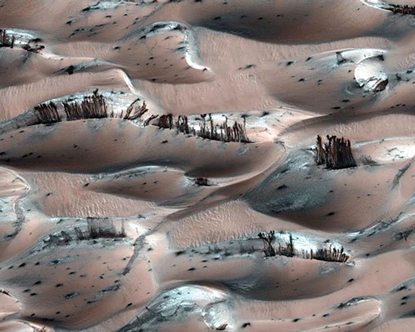
Martian “Trees”
In 1976, the Viking 1 orbiter photographed the famous “Face on Mars” which made everyone think there was possibly intelligent life on the Red Planet. This was later disproven as nothing more than a natural geological formation, but it hasn’t stopped the phenomenon of seeing faces and shapes in random objects—also known as pareidolia—from taking hold, as seen in this HiRISE image from Mars’ north pole.
At first glance, the above image does give the appearance of actual trees growing on the surface of Mars, which would indicate signs of life. But this is merely an illusion, much like the “Face on Mars”. The “trees” that you’re actually seeing in this false color image from HiRISE are actually dark basaltic sand having been pushed to the surface of sand dunes by sun-heated solid carbon dioxide ice, also known as dry ice, that has sublimated—evaporated—into a vapor.
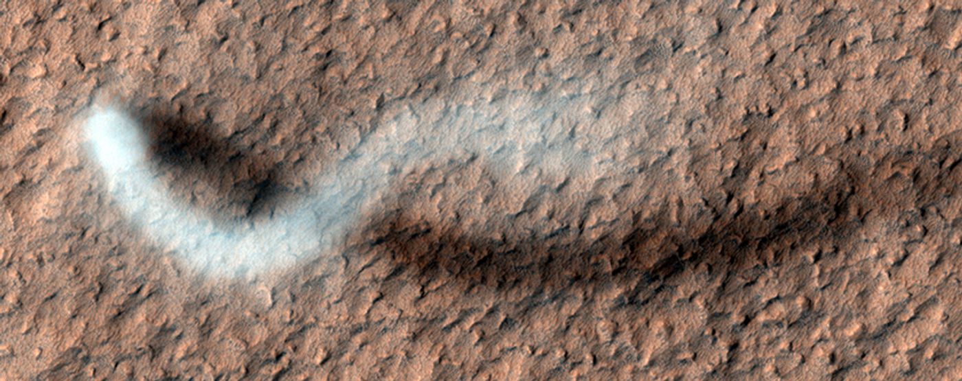
Dust Devil
Unlike the aforementioned “trees”, this next image isn’t an illusion. This is a standard Martian dust devil whose plume is about 30 meters (98 feet) in diameter streaking across Amazonis Planitia. The shadow length of the plume indicates that it reaches more than 800 meters (2624 feet), or half a mile, into the sky, as it scurries across the surface, cleaning it as it goes.
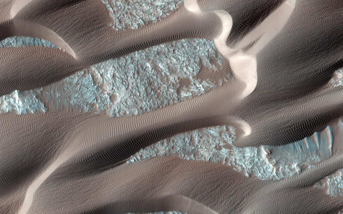
Sand Dunes in Nili Patera
Nili Patera is a very active dune field on Mars, located on top of a solidified lava bed near the Martian equator at the site of an ancient volcano, the Nili Patera caldera of Syrtis Major. This particular image, acquired in 2014, has been an area of interest for scientists, who use HiRISE to monitor the dune activity every few months. Here, you can see obvious dune migration based on the countless ripples, and the lee faces of the dunes, or the part of the dune facing away from the wind—bright face—demonstrate recent avalanches.
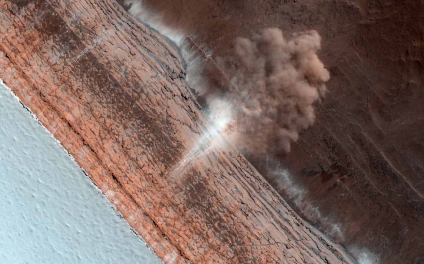
Mars Avalanche
The following image shows a literal avalanche in progress in the north polar region of Mars, which can be caused by either the thawing of carbon dioxide ice or marsquakes. While the overall temperatures on Mars are much colder than Earth, the Red Planet still experiences seasons where it’s colder in the winter and warmer in the spring and summer. In the case of Mars, this “warmer” weather often leads to frozen carbon dioxide ice thawing. In terms of marsquakes, geologists have seen seismic shocks as powerful as magnitude-7 here on Earth.
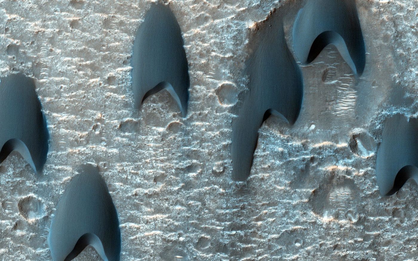
“Starfleet Insignia” Sand Dunes
While this image resembles a certain sci-fi series symbol, they’re actually sand dunes in Mawrth Vallis, also known as barchan dunes. The spacing of such dunes are often the function of sand supply, wind speed, and topography, and they can form when the wind blows predominantly in one direction.
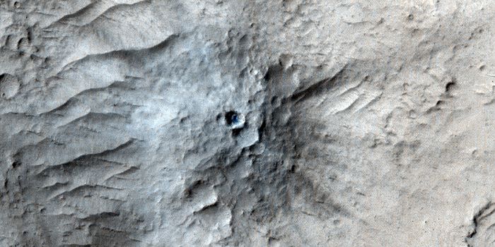
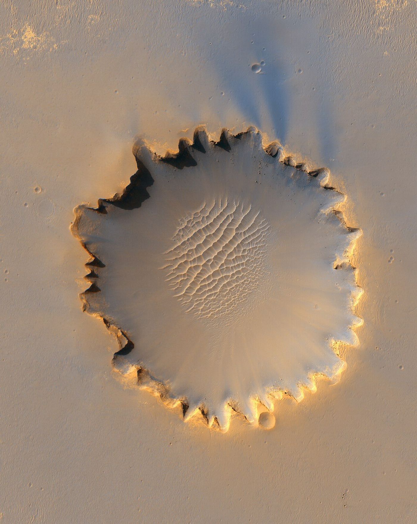
Victoria Crater
This impact crater at Meridiani Planum near the Martian equator is approximately 800 meters (2624 feet), or half a mile, in diameter. Note how this crater’s diameter is equal to the approximate height of the dust devil presented earlier. Its distinctive scalloped-shaped rim is likely caused by erosion and downhill movement of crater wall material. A striking field of sand dunes is clearly visible on the crater’s floor while layered sedimentary rocks are also exposed along the inner walls.
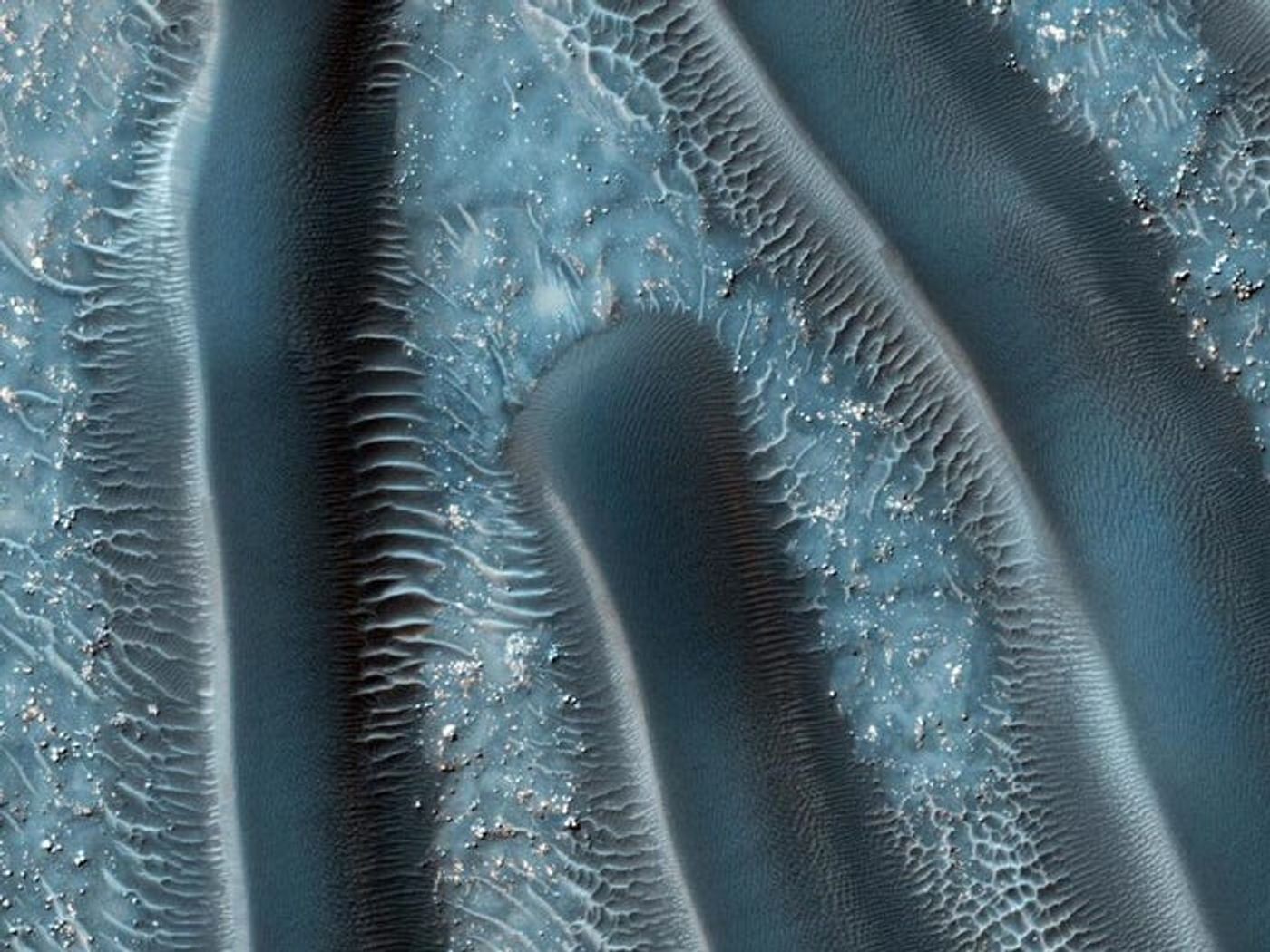
Martian “Millipedes”
The “Face on Mars” and carbon dioxide ice “trees” we discussed earlier are two of countless places on Mars where pareidolia is present, and the sand dunes in this image are definitely an excellent example, as one might mistake them for millipedes. These dunes are similar to the “Starfleet” barchan dunes discussed earlier, as their spacing is often sensitive to subtle shifts in wind circulation patterns and wind strength.
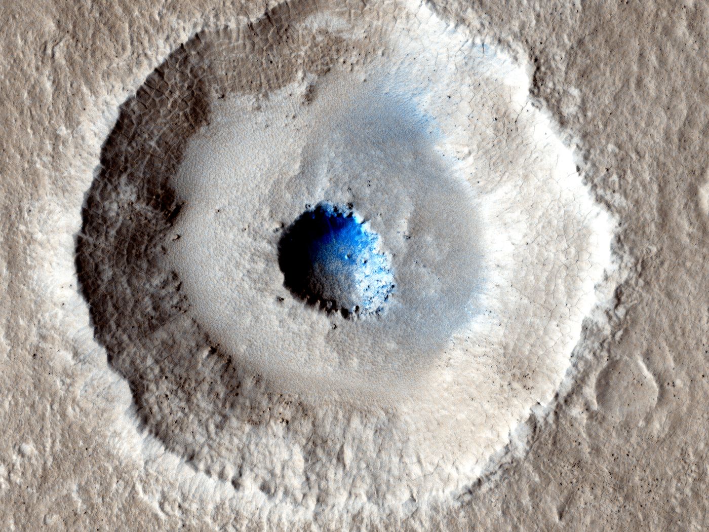
Icy Surface Crater
Mars is covered in ice, some made of water and some carbon dioxide, but another thing the Red Planet is covered in are craters. Lots and lots of craters. Combine the two and you get an amazing image, as depicted here by this terraced crater. Such a crater is often made if the underground material changes from weak to strong, and this particular crater indicates the upper surface is most likely made of ice.
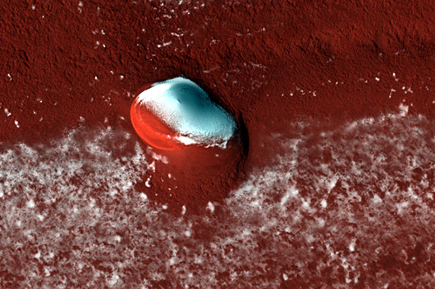
“Oyster” Crater
This oddly shaped crater in the north polar region of Mars looks spectacular in false color showing the stark contrast between the ice deposits and layered deposits. But this crater also carries the distinction of being the sole impact crater for miles, indicating the layered deposits in this region of the planet could only a few million years old. This relative age is often determined by crater counting, where craters are literally counted in a specified area where the lower the count, the younger the surface is.
While Mars has seen a plethora of missions from several nations over the last half-century, none have displayed Mars in breathtaking beauty as the HiRISE camera onboard MRO. This camera continues to change the way we literally see Mars and will continue to help us better understand our Red Planet neighbor for years to come. HiRISE may even help bring about better cameras used on future missions to either Mars or other planets in the solar system.
As always, keep doing science & keep looking up!
Sources: Labroots, NASA Space Science Data Coordinated Archive, NASA Radioisotope Power Systems, CNN, Mars Exploration Rovers, Mars Exploration Program (1), Mars 2020 Mission Perseverance Rover, NASA MRO, NASA HiRISE, NASA Goddard Space Flight Center, Smithsonian Magazine, NASA, Space.com (1), Lunar & Planetary Laboratory (1), Wikipedia (1), AmericaSpace, Wikipedia (2), Mars Exploration Program (2), NBC News, Space.com (2), Lunar & Planetary Laboratory (2), Lunar & Planetary Laboratory (3), Lunar & Planetary Laboratory (4)