LiDAR, archaeologists joke that it’s ‘the dream’ when approaching large-scale field surveys, especially in remote or difficult to traverse areas. It seems like new 'lost' cities are coming to light every couple of years thanks to LiDAR. But what is it, and how does it work?
LiDAR stands for Light Detection and Ranging and has made finding hidden structures deep in forested and jungle environments considerably easier for archaeologists over the past decade. While the technology has been around longer, it was often cost prohibitive to carry out LiDAR surveys. Now, LiDAR can be used more frequently as a method of remote sensing via unmanned aerial vehicles (UAVs) to essentially see through thick forests and canopies from the air to the ground. Allowing us to identify and map previously unknown archaeological sites.
LiDAR essentially works by bouncing a laser off of a targeted object or surface and measuring the time it takes for the beam to return to the receiver, in this case mounted on a UAV.
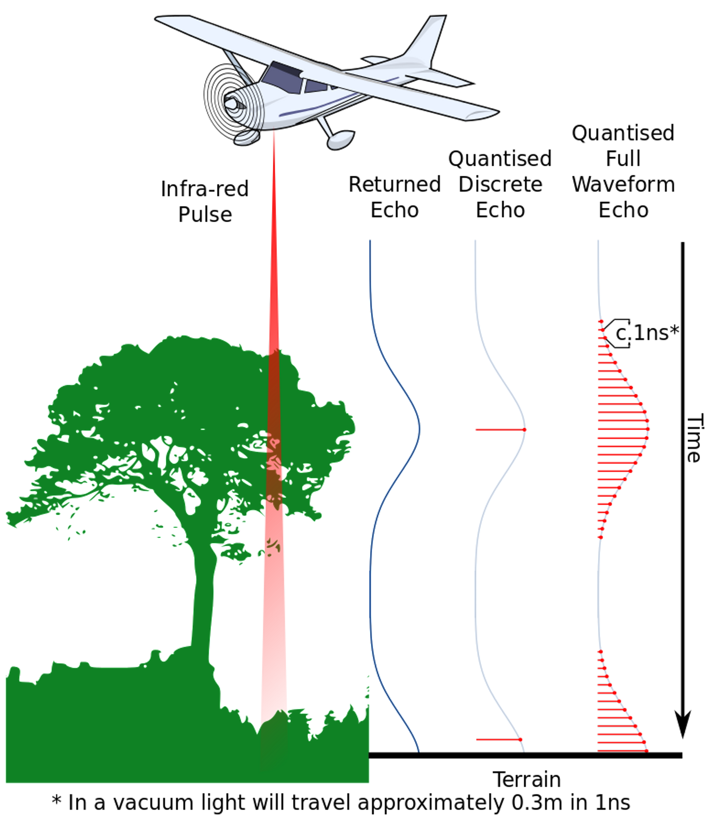
Figure 1: Showing how LiDAR works using lasers mounted on aerial vehicles. Image Credit: Anthony Beck. This file is licensed under the Creative Commons Attribution-Share Alike 3.0 Unported license.
Measurements are taken from throughout the desired area and assembled into 3D measurements or ‘point cloud data.’ These data can then be rendered to create both horizontal and vertical 3D landscape recreations from the ground level, essentially disregarding any heavy vegetation. This allows archaeologists to see through heavy vegetation to the ground level without having boots on the ground (although this is still nice to have in terms of a comprehensive survey when possible).
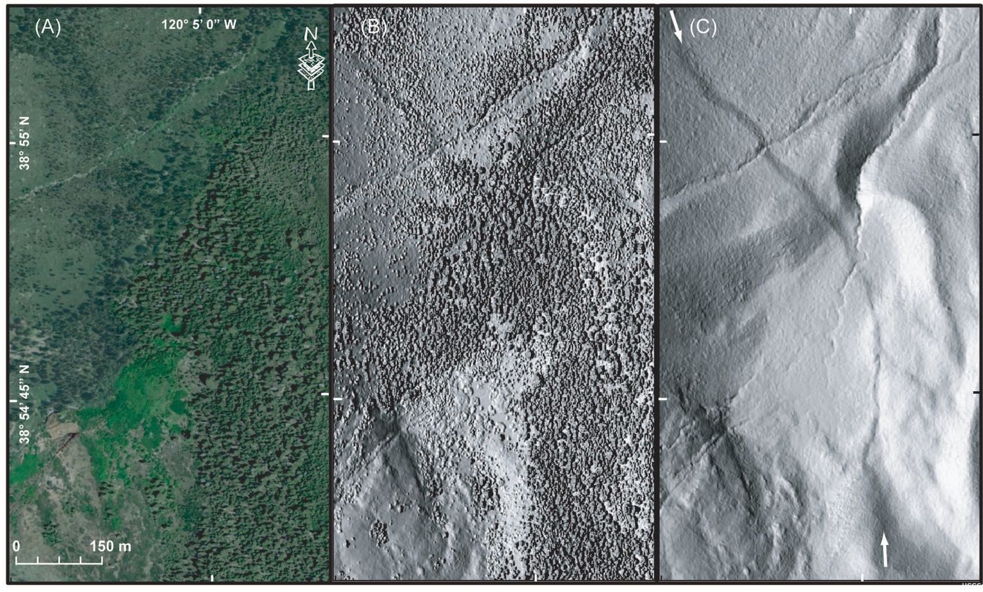
Figure 2: Three images showing the progression of LiDAR technology in an area near Lake Tahoe, California. From left to right, (A) aerial ortho photo showing an area covered by dense vegetation that obscures the landscape; (B) same area with preliminary LiDAR images; (C) same area with final LiDAR imagery removing the tree cover, and showing the bare terrain. Image Credit: : Earth Resources Observation and Science (EROS) Center.
Not only can this method identify archaeological features and structures like those recently publicized in the Amazon, but the technique can also aid in identifying damage to archaeological sites (looting & environmental damage), deforestation, coastal changes, modern construction, and more. While extremely dense vegetation can result in lasers not quite reaching the ground level, the technique is still nothing short of a ‘revolution’ for many archaeologists.
LiDAR has been utilized in heavily forested/jungle areas to identify previously unknown or difficult to access archaeological sites. Even ‘low-resolution’ LiDAR surveys can identify massive archaeological complexes.
The recent study of pre-Hispanic urban sites in the Bolivian Amazon, published in Nature yesterday (May 25, 2022) revealed two large urban sites belonging to the Casarabe culture (dating from ca. 500-1400 CE) using LiDAR. These sites are important because, other than some reports of low-density urbanism at sites in the tropical forests of Southeast Asia, Sri Lanka and Central America, this type of site has not been identified in Amazonia until now.
Time will show just how many sites can be identified with this method as technologies advance.
Sources: National Geographic, Springer, PNAS, WSJ Science, Science News, Nature, Archaeological Prospection